


 English (pdf)
 Article in xml format
 Article references
 Send this article by e-mail
 Cited by SciELO
  Similars in
SciELO
Similars in
SciELO  uBio
uBio 
 Permalink
INTRODUCCIÓN
The South American Gran Chaco, which occupies part of Argentina, Bolivia and Paraguay, is an area undergoing full agro-livestock development in all three of these countries, and particularly in Paraguay (1), where less than ten years ago, its natural plant formations remained considerably undegraded. The fragmentation of ecosystems and the loss of ecological connectivity are caused by human activities (2-6) and less frequently due to major natural disasters. Within the last 30 years, the Gran Chaco has become a center for agricultural intensification and expansion. In Argentina, forests have been replaced with croplands, while in Paraguay changes in land use have been mainly for the implantation of cattle pastures. The Bolivian Chaco has been the least modified area 1).
The Gran Chaco is the second most extensively forested region in South America; these forests are combined with shrublands and a wide variety of environments such as dry and hydromorphic savannas, marshes, wetlands, hill ranges, rivers and salt flats 7). The advance of productive activities is degrading these natural environments, and there is an urgent need for the use of ecological tools to help reduce further fragmentation of these natural formations before they disintegrate completely. The fragmentation of natural areas affects the survival of certain species, and protected areas alone are generally not enough to ensure stable populations in the regions 8. The implementation of connecting areas such as ecological corridors constitute a key tool for providing resilience, and in some cases even reaching a homeostasis of the natural remnants. Thanks to the continuity of these corridors, a strategy to support the conservation of biodiversity would be achieved, allowing for the permanence and movement of various species.
Connectivity is the degree to which a landscape facilitates or hinders the movement of wildlife between favorable habitats 9, thus enabling or limiting significant ecological processes, such that the preservation of connectivities minimizes the effects of the fragmentation of the habitat 10. One way to contribute towards reducing the loss of ecological connectivities consists of designing ecological corridors as zones that buffer the negative effects of fragmentation 6).
According to 11, an ecological corridor was originally conceived as a linear habitat that differs from the matrix and that connects two or more natural fragments. This concept, however, has since evolved in a more general and comprehensive manner by considering other aspects of the landscape, such as soil types, and which is used to connect forest fragments throughout the landscape 12,13).
Some authors, such as 14, mention that ecological corridors are strips of vegetation incorporated into the landscape to influence ecological processes, provide goods and services, and serve as passages for wildlife (greenways, windbreaks and others); meanwhile others, such as Tres & Reis 15), mention that many of these models fill the corridors with tree species that in the long run limit the space available for natural regeneration.
The South American Chaco in the Pilcomayo River area: an overview
The South American Gran Chaco region covers around one million square kilometers, 16 and presents similar climate and soil characteristics throughout, as well as plant communities and species, which have been mentioned by various authors 17, -34, among others). From a hydrographic point of view, the area includes the rivers Timane, Bermejo and Pilcomayo 25, whose source, sub-basin and delta are the main focus of this work and represent one of the most important ecological corridors in the Chaco region, together with the Paraguay and Bermejo rivers and all their tributaries.
The Shared Management Area (SMA) encompasses the trinational Pilcomayo River area, in the heart of the South American Gran Chaco, and finds itself surrounded by the agro-livestock expansion experienced in the region. The Pilcomayo River originates in Bolivia and flows within a canyon formed by the Cordillera del Aguaragüe (Aguaragüe hill range), and further south, between Yvybobo ENT#091;21°32’S - 62°59’WENT#093; and Villa Montes ENT#091;21°15’59”S - 63°27’3”WENT#093;, it enters a plateau dragging about 50 tons/year of sediments, with a highly variable flow volume, often suffering from the siltation or plugging of its own channel 35. From the hydro-ecological point of view, these changes are highly important since they form secondary meanders, various kinds of shallow water and lagoons, swales and others, limited by ridges 36, which help to alleviate the conditions of aquatic-palustrine dependent animals and plants, and resulting in excellent natural ecological corridors.
The need to establish connectivity between key sites for biodiversity was highlighted during the Second Ecoregional Assessment (Tarija, 2018), where it was agreed to focus on this as a main task. One of the reasons is the rich and specific diversity of the region where the SMA is located, considering the numerous changes in the use of forested areas and other types of formations to other productive systems such as agro-livestock farming, especially in Paraguay. It is hoped that this will help to reverse the loss of natural cover, the fragmentation of habitat, the lack of land use planning, the use of inappropriate agricultural practices, and the loss of water resources, among others 12, while supporting the sustainable development of the region.
Two different situations arise within the shared management area: a) the Paraguayan Chaco scenario, where major changes in land use can be observed, and b) the Argentine and Bolivian Chaco scenario, where these major changes have not flourish. It is intended that the area must not lose its characteristic of being a great corridor along the Pilcomayo River and that the connectivity proposal could thus be incorporated within the development of land use planning.
The objective of this work is to determine, through the analysis of existing data, the best design of ecological corridors that guarantees the connectivity of key biodiversity sites, without resulting in a high cost for fauna, while also ensuring the sustainable development of the Pilcomayo region.
MATERIALS AND METHOD
Climatic and biophysical characteristics of the study area
The SMA is located entirely within the sub-basin of the Pilcomayo River, which occupies part of the Argentine provinces of Formosa, Salta and Jujuy, the Paraguayan departments of Boquerón and Presidente Hayes, and the Bolivian department of Tarija. The dynamic river acts as the main axis on which a rectangular study area of 16,253,067 hectares has been delimited (Fig. 1).
The design was extended beyond the limits of the SMA to link connectivity with the entire South American Gran Chaco, through corridors designed for each of the countries affected 37).
Figure 1: Study area for corridor design that includes The Shared Management Area, SMA.
The climate in the SMA ranges from semi-arid, for the most part, to sub-humid towards the Paraguay-Pilcomayo Mesopotamia in Paraguay; a variable rainfall regime with a steep gradient range between 1200-1300 mm per year in the Presidente Hayes Department (Paraguay) and the Formosa Province (Argentina), to 500 mm per year over the semi-arid Chaco in the rest of the area 38,39.
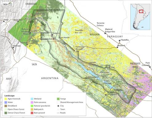
Figura 1: Área de estudio para el diseño de corredores que incluyen el Área de Gestión Compartida, AGC.
Soils also vary throughout the region. At the higher altitudes, found around the Aguaragüe hill range, Bolivia, they present a dominance of partially consolidated coarse-grained sands. Down in the plains, a dominance of clays and silts and enclaves of hydric sands carried by the river can be observed 39. Biotic elements, however, are quite similar and they share types of plant formations and common species. In Argentina, the area included in this study occupies the ecoregions known as Dry Chaco and Humid Chaco, in the provinces of Salta and Formosa. In Paraguay, the ecoregions are also named the same and include the departments of Boquerón and Presidente Hayes.
The xerophytic and sub-humid plant formations and their components are very similar, with extensive hydromorphic savannas with Copernicia alba; sub-humid forests with Schinopsis cornuta, S. quebracho-colorado, Sarcomphalus mistol, Geoffroea decorticans, Gonopterodendron sarmientoi, Salta triflora, Stetsonia coryne, Bulnesia foliosa, among others; typical azonal formations of the site such as the so-called peladares (bald patches) with G. sarmientoi and S. coryne, that developed on paleochannels recently formed and silted-up by the Pilcomayo River; gallery forests and flooded forests with Neltuma alba, Vallesia glabra, Solanum argentinum, among others. Other highly important systems include the wetlands with marshes and small, shallow lagoons, with aquatic-palustrine vegetation. In Bolivia, the landscape is different because the Pilcomayo River has two stages: the first where it flows swiftly within an enclosed channel down the Aguaragüe hill range, where the Yungas develop, and the second stage where the river opens and widens onto the Chaco plain, depositing much of its alluvial sediment. Both landscape types are visible from the city of Villa Montes ENT#091;21°15’59” S - 63°27’3” WENT#093;. All these plant formations and associations found within the SMA have been widely studied by several authors, such as 23,38,26,27,30,32,40,41,42,43,44,45,34, among others.
The Chacoan fauna throughout the area is also very similar and very rich, with a great diversity of mammals, birds and reptiles, which have also been widely studied by several authors (46-51), among others.
Stages of the study
Identification of High Conservation Value Areas (HCVAs): or areas with healthy environmental conditions, which can host viable populations of the species of interest for which the corridors have been designed. These included protected areas with official national or international protection status, wetlands, forest areas with certification for sustainable use, protected productive landscapes, among others. Fourteen reserve areas were included, representing a total area of 1,010,814 hectares; two of these are in Bolivia, five in Argentina and six in Paraguay, representing 12%, 65% and 23% for each country, respectively. One additional area is shared between Bolivia and Paraguay by two bordering private nature reserves: El Corbalán and Cañada El Carmen (Table 1, Fig. 2).
Table 1. High Conservation Value Areas of the three countries to be connected.
Of the nucleus zones or reserve areas included to establish connectivities (Fig. 2), 77% of the surface area corresponds to forests (xerophytic forest and yungas), while another 6% corresponds to anthropized areas (agro-livestock and urban). Seven of the conservation areas are located within the SMA between the three countries (74%), while the remaining are external and were included to link the connectivity strategy of the shared area at a regional scale.
Table 1 High Conservation Value Areas (HCVA) of the three countries to be connected.
| Code | Name | Label | Category | Jurisdiction | Country | Surface area (has) |
|---|---|---|---|---|---|---|
| 1 | Aguaragüe | Aguaragüe | National Park and Integrated Management Natural Area | National | Bolivia | 119,014 |
| 2 | La Ceiba | La Ceiba | Bolivia | 912 | ||
| 3 | Reserva Natural Cañada El Carmen y El Corbalán | Carmen-Corbalán | Nature Reserve | Private | Paraguay-Bolivia | 10,084 |
| 4 | Reserva Natural Arcadia | Arcadia | Nature Reserve | Private | Paraguay | 5,073 |
| 5 | Pilcomayo Salta | Pilcomayo Salta | Category OTBN | Provincial | Argentina | 40,611 |
| 6 | Reserva Natural Palmar Quemado | Palmar Quemado | Nature Reserve | Private | Paraguay | 10,357 |
| 7 | Reserva Natural TSM | TSM | Nature Reserve | Private | Paraguay | 1,237 |
| 8 | Reserva Natural Toro Mocho | Toro Mocho | Nature Reserve | Private | Paraguay | 18,940 |
| 9 | Tinfunqué | Tinfunqué | Managed Resources Reserve | National | Paraguay | 187,334 |
| 10 | Toldo Cué | Toldo Cué | Protected Area | Private | Paraguay | 1,049 |
| 11 | Reserva de Caza Agua Dulce | Agua Dulce | Hunting Reserve | Provincial | Argentina | 8,674 |
| 12 | Bañado la Estrella | La Estrella | Public Nature Reserve | Provincial | Argentina | 408,355 |
| 13 | Riacho Teuquito | Teuquito | Biosphere Reserve | Argentina | 163,046 | |
| 14 | El Impenetrable | El Impenetrable | National Park | National | Argentina | 36,127 |
Figure 2. High Conservation Value Areas of the three countries to be connected in The Shared Management area, SMA (refer to Table 1 for the identification codes of the HCVAs).
Interconnection network: once the areas to be connected were identified, a minimum network of connections was designed to secure communication between them, to identify a priori which are the minimum fundamental connections that guarantee the interconnection of the entire system. This analysis was carried out using the minimum spanning tree calculation. This algorithm defines the optimal network of least-cost links between regions 53. In this case, proximity is not defined in terms of Euclidean distance, but rather as a distance weighted by a friction value assigned to a cost matrix.
Cost surface: we worked with a cost surface that quantitatively estimates how certain ecological-environmental parameters, as well as others of anthropic origin (roads, towns, reservoirs), affect the movement of fauna species 54. Lower values in the cost matrix indicate ease of movement, while higher values indicate movement restrictions or even a barrier (Table 2). Four environmental variables that influence the movement of large land mammals were considered. These variables were subsequently transformed into resistance values, based on consultation with experts and a literature review 55,56,57. The variables were land cover, outpost/community distances, distances to roads and distances to rivers. The matrices and surface costs are detailed in Tables 1 and 2, as well as in Figure 3.
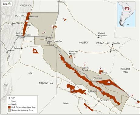
Figure 2 High Conservation Value Areas of the three countries to be connected in The Shared Management area, SMA (refer to Table for the identification codes of the HCVAs).
Figura 2. Áreas de Alto Valor de Conservación de los tres países que se conectará en el área de Gestión Compartida, AGC (consulte la Tabla 1 para los códigos de identificación de los HCVAs).
Table 2. Costs assigned to the criteria of roads, rivers and outposts/communities, used in the definition of the cost surface. Ranges of distances assigned and the costs of each.
For natural landscapes, the movement costs were applied to each type of cover and combined in a single layer from a linear sum, thus obtaining the cost surface of the landscape (Table 3, Figure 2).
Table 2 Costs assigned to the criteria of roads, rivers and outposts/communities, used in the definition of the cost surface. Ranges of distances assigned and the costs of each.
| Roads | Rivers | Outposts/Communities |
|---|---|---|
| Class (m) Cost | Class (m) Cost | Class (m) Cost |
| 0-60 1 | 0-5000 1 | <1000 8 |
| 60-500 2 | 5000-20000 2 | 1000-3000 4 |
| 500-1500 5 | >20000 3 | >3000 1 |
| >1500 9 |
Table 3 Costs assigned to the various environments (types of land cover), for the definition of the cost surface.
| Environments | Cost |
| Open Chaco Forest | 1 |
| Dense Chaco Forest | 1 |
| Yunga | 8 |
| Palm savanna | 2 |
| Shrubland | 3 |
| Natural grasslands | 3 |
| Bald patch | 4 |
| Wetland | 2 |
| Water | 3 |
| Bare ground | 6 |
| Agro-livestock | 8 |
| Urban | 10 |
The land cover was updated to 2019 and was built upon a supervised Sentinel scene classification (Fig. 3). The outposts/communities variable represents the presence and influence of small human groups on the natural environment, including cattle ranches and farms in Paraguay, as well as the indigenous communities of the three countries (Tables 2 and 3, Fig. 4). We worked with a resolution of 10 m. The cost values were standardized to 1 (minimum cost for the movement of species) and 10 (maximum cost).
Figure 3. Costs assigned to the criteria used in the definition cost surface for the design of biological corridors within The Shared Management Area.
Definition of Biological Corridors: once the nuclei and patches to be connected and the cost matrix to be used were defined (Fig. 4), the optimal routes were determined through the cost surfaces, using the Cost Distance function of the ArcGIS Spatial Analyst. This function calculates the accumulated costs from the conservation nuclei, considering distance and direction. These assembled grids were used as inputs to the ArcGis Spatial Analyst Corridor function, which determines the least-cost corridors between pairs of nuclei.
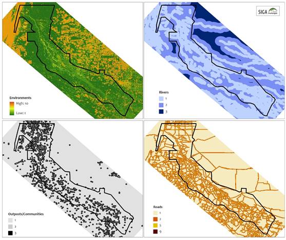
Figure 3 Costs assigned to the criteria used in the definition cost surface for the design of biological corridors within The Shared Management Area.
The Bolivian portion of the Pilcomayo River was defined as a fluvial corridor, by delimiting a kilometer-wide buffer zone around the river and its banks, which makes up its lamination zone once the enclosed channel opens near the city of Villa Montes (Bolivia). The widths of the established corridors were variable.
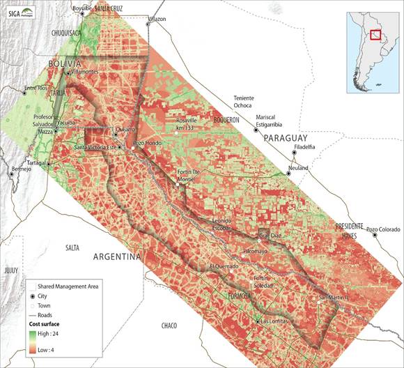
Figure 4 Cost surface based on land cover type, distance to outposts/communities, waterways and roads, used for the design of biological corridors within The Shared Management Area, SMA.
Figura 4. Superficie de costos basada en el tipo de cobertura terrestre, distancia a puestos avanzados / comunidades, vías fluviales y carreteras, utilizada para el diseño de corredores biológicos dentro del Área de Gestión Compartida, AGC.
Results/Resultados
Fourteen biological corridors were defined, totaling an approximate area of 615,926 hectares and working as a network between the reserve areas that ensures connectivity between them (Figs. 5 and 6, Table 4). Of the area occupied by biological corridors 53% corresponds to Argentina, 19% to Bolivia and 27% to Paraguay. The Pilcomayo River Corridor is the largest, while the La Estrella-Tinfunqué corridor has the smallest surface area (Table 4).
Table 4 Details of the biological corridors and their connections, within The Shared Management Area, SMA.
| Code | Corridor | Surface Area (has) | % of Area |
| 1 | Carmen Corbalán-Arcadia | 53,688 | 8.72 |
| 2 | Ceiba-Carmen Corbalán | 48,815 | 7.93 |
| 3 | Pilcomayo | 98,352 | 15.97 |
| 4 | Ceiba-Pilcomayo Salta | 92,842 | 15.07 |
| 5 | Aguaragüe-Pilcomayo Salta | 64,522 | 10.48 |
| 6 | Pilcomayo Salta-La Estrella | 70,961 | 11.52 |
| 7 | La Estrella-Palmar Quemado | 20,700 | 3.36 |
| 8 | La Estrella-TSM | 23,098 | 3.75 |
| 9 | Tinfunqué-Toro Mocho | 32,071 | 5.21 |
| 10 | La Estrella-Tinfunqué | 11,982 | 1.95 |
| 11 | La Estrella-Teuquito | 20,814 | 3.38 |
| 12 | Teuquito-El Impenetrable | 46,864 | 7.61 |
| 13 | Tinfunqué-Toldo Cué | 15,762 | 2.56 |
| 14 | Toldo Cué-Agua Dulce | 15,455 | 2.51 |
Figure 5. Biological Corridors within The Shared Management Area, SMA (refer to Table 4 for the identification codes of the BCs).
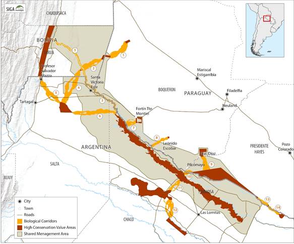
Figure 5 Biological Corridors within The Shared Management Area, SMA (refer to Table 4 for the identification codes of the BCs).
Figura 5. Corredores Biológicos dentro del Área de Gestión Compartida, SMA (consulte el cuadro 4 para los códigos de identificación de los CBs).
Figure 6. Types of environments found within the biological corridors in The Shared Management Area, SMA (refer to Table 4 for the identification codes of the BCs).
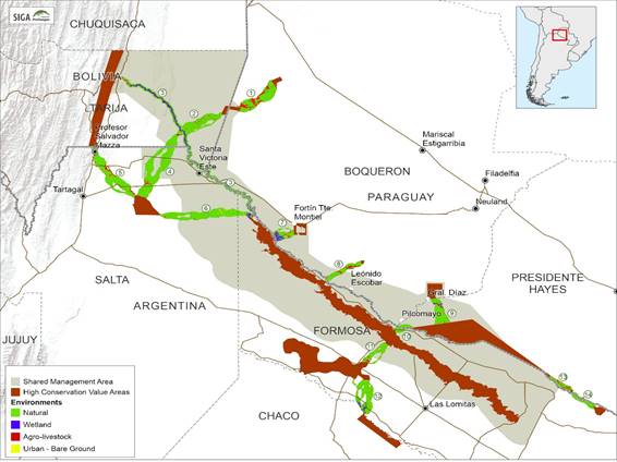
Figure 6 Types of environments found within the biological corridors in The Shared Management Area, SMA (refer to Table 4 for the identification codes of the BCs).
Figura 6. Tipos de ambientes que se encuentran dentro de los corredores biológicos en el Área de Gestión Compartida, AGC (consulte la Tabla 4 para los códigos de identificación de los CBs).
DISCUSSION AND CONCLUSIONS/CONCLUSIONES Y DISCUSIONES
Maintaining connectivity between important biodiversity HVCAs is what is sought with the design and subsequent implementation of biological corridors on the ground, and even more so in the case of the Chaco region, a last representative stronghold of dry and sub-humid forests that still harbors a considerable number of emblematic species of wild flora and fauna (37). Although the surfaces covered by the biological corridors are very important, the connectivity that may exist between these corridors is no less important. The more intertwined and connected they are, the more opportunities for wildlife -especially mammals- to survive.
Connectivity corridors are a tool that helps to build a territorial ordering, connecting small nucleus zones while leaving areas set aside for production, in addition to protecting areas that are not usually included within the normal system of legally declared protected natural areas, bearing in mind that these are in private areas, which can also offer other benefits such as environmental services.
Nevertheless, biological corridors are still a controversial issue. When prioritizing important biodiversity nuclei, in many cases sites with wildlife concentrations are selected, such as permanent or temporary water sites (lagoons, waterholes, streams, others) that have a low cost for fauna, which is normal in xerophytic environments; however, at the same time, these sites frequently become prone to the hunting of birds and mammals, which in turn represents a high cost for them.
The current situation must prioritize the conservation of threatened and endangered fauna, such as big cats, and include within the connectivity the protected productive landscapes such as crops, private reserves and windbreaks. These are used by all kinds of fauna to travel back and forth, and this has been confirmed with camera trap imagery.
Although the connectivities are designed mainly for the passage of fauna, it is very important to take into consideration the vegetation and other natural systems that are also key to the conservation of biodiversity. Although this would seem most logical, the current problem -for which methods that include anthropic costs are employed- is that changes in land use have preceded the territorial ordering plans implemented in areas such as the Chaco, which are in full development.
Given that SMA is extensive and encompasses several ecoregions in all three countries, it was necessary to incorporate the most typical plant formations from each of them, so that they remain as core areas and connect the most outstanding ecosystems that occur along the Pilcomayo River and within its surroundings, such as: the hydromorphic savannas of Copernicia alba; the dry forests with Schinopsis cornuta, S. quebracho-colorado, Aspidosperma quebracho-blanco, and Gonopterodendron sarmientoi; the sub-humid forests with Schinopsis balansae; the yungas with Myroxylon peruiferum, Juglans autralis, and Cascaronia astragalina; Amburana cearensis and Pseudobombax in the Aguaragüe hill ranges; and the riparian areas with Neltuma alba and Vallesia glabra among the most noteworthy, as well as the large areas of wetlands with permanent and temporary water with aquatic-palustrian vegetation, which harbor a rich and characteristic flora and fauna of the Chaco, typical of the Pilcomayo River area (detailed in Table 5). Despite their fragmentation, they continue to maintain important components 58, of the Chaco and Pilcomayo fauna. Corridors also elude the negative effects of fragmentation and improve the prospects for biodiversity in both natural and urban environments 59-63).
Tabla 5. Tipos de cobertura del Corredor Biológico, superficies y porcentajes, dentro del Área de Gestión Compartida, AGC
Table 5 Types of Biological Corridor cover, surface areas and percentages, within The Shared Management Area, SMA.
| Environment | Environment Detail | Surface Area (has) | Surface Area (%) |
| Natural | Open Chaco Forest | 322,053 | 52.29 |
| Natural | Dense Chaco Forest | 148,240 | 24.07 |
| Natural | Yunga | 5,464 | 0.89 |
| Natural | Palm Savanna | 7,939 | 1.29 |
| Natural | Shrubland | 14,304 | 2.32 |
| Natural | Natural Grassland | 456 | 0.07 |
| Natural | Bald Patch | 25,852 | 4.20 |
| Wetland | Wetland | 19,223 | 3.12 |
| Wetland | Water | 22,613 | 3.67 |
| Urban-Bare Ground | Bare Ground | 13,569 | 2.20 |
| Productive | Agro-livestock | 34,901 | 5.67 |
| Urban-Bare Ground | Urban | 1,313 | 0.21 |
The design of the corridors is quite simple on paper, though this is not always so simple on the ground. One or more variables, that can be either physical, legal, biological or even social and economic, must all be considered. Consequently, the socioeconomic aspect was included in the design 62, considering the populations found in the area and their activities (Tables 2 and 3, Fig. 2). Indeed, in this region, the resident populations are mostly native to the area and depend on the shifting of the water, without paying much attention to the political boundaries. Therefore, it would be of greater benefit for them that the natural ecosystems be maintained, with a greater resilience resulting from the corridors, and that they be supported in their economic activities, such as the production of honey, artisan crafts and products derived from the native flora (such as basket weaving), the fruits and roots used for food, as well as the protein sourced from wild fauna.
The connectivity corridors should provide continuity within the territories of each of the countries, or they would fail to fulfill their connecting role, especially those that link important nuclei 37. The nuclei in turn should also be evaluated periodically; not just the connectivities. It is for this reason that the type of management implemented will be of utmost importance to ensure the positive results of the connections on the ground. In many cases, it will be necessary to take advantage of the already existing natural patches of vegetation to facilitate the effective implementation of the corridors. 63 mentions, the greater the connectivities, the greater the fauna's expectations for its survival.

